Japan's tsunami debris heads
towards North America
Nuclear Power Radiation
EMF Computer Protection
Magnetic Field Detector
January 02, 2012
Debris from the tsunami that
devastated Japan in March 2011 could reach the United States
as early as this winter, according to predictions by NOAA
scientists. However, they warn there is still a large amount
of uncertainty over exactly what is still floating, where
it's located, where it will go, and when it will arrive.
Responders now have a challenging, if not impossible
situation on their hands: How do you deal with debris that
could now impact U.S. shores, but is difficult to find?
Federal Agencies Join Forces
To learn more about the tsunami
debris, NOAA researchers have been working with the U.S.
Environmental Protection Agency, U.S. Fish and Wildlife
Service, and other partners to coordinate data collection
activities.
NOAA and its partners are also
coordinating an interagency assessment and response plan to
address the wide-range of potential scenarios and threats
posed by the debris.
“We’re preparing for the best
and worst case scenarios — and everything in between,” says
Nancy Wallace, director for NOAA’s Marine Debris Program.
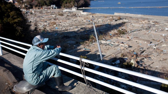
As the tsunami surge receded, it
washed much of what was in the coastal inundation zone into
the ocean. Boats, pieces of smashed buildings, appliances,
and plastic, metal, and rubber objects of all shapes and
sizes washed into the water — either sinking near the shore
or floating out to sea. The refuse formed large debris
fields captured by satellite imagery and aerial photos of
the coastal waters.
The Japanese government
estimated that the tsunami generated 25 million tons of
rubble, but there is no clear understanding of exactly how
much debris was swept into the water nor what remained
afloat.
What remains of the
debris?
Nine months later, debris fields
are no longer visible. Winds and ocean currents scattered
items in the massive North Pacific Ocean to the point where
debris is no longer visible from satellite. Vessels
regularly traveling the North Pacific have reported very few
sightings. Only two pieces have been clearly linked to the
tsunami.
NOAA is coordinating new
interagency reporting and monitoring efforts that will
provide critical information on the location of the marine
debris generated by the tsunami. Ships can now report
significant at-sea debris sightings and individuals or
groups can request shoreline monitoring guides at DisasterDebris@noaa.gov.
Where is it?
Computer models run by NOAA and
University of Hawaii researchers show some debris could pass
near or wash ashore in the Northwestern Hawaiian Islands (in
the Papahânaumokuâkea Marine National Monument) as early as
this winter, approach the West Coast of the United States
and Canada in 2013, and circle back to the main Hawaiian
Islands in 2014 through 2016.
Researchers caution that models
are only predictions based on location of debris when it
went into the water, combined with historical ocean currents
and wind speeds.
Conditions in the ocean
constantly change, and items can sink, break down, and
disperse across a huge area. Because it is not known what
remains in the water column nor where, scientists can’t
determine with certainty if any debris will wash ashore.
Worst- and Best-case Scenarios
The worst-case scenario is boats
and unmanageable concentrations of other heavy objects could
wash ashore in sensitive areas, damage coral reefs, or
interfere with navigation in Hawaii and along the U.S. West
Coast. Best case? The debris will break up, disperse and
eventually degrade, sparing coastal areas.
Debris will not go away
completely, even in a best-case scenario. Marine debris is
an ongoing problem for Hawaii and West Coast states, where
garbage and other harmful items regularly wash up on
beaches, reefs and other coastal areas.
NOAA has convened experts to review available data and
information from models and provide their perspectives on
debris fate and transport. They are gathering information on
significant sighting of marine debris in the North Pacific
through NOAA’s Office of Marine and Aviation Operation’s
Pacific fleet, the NOAA Voluntary Observing Ship Program,
which includes industry long-haul transport vessels, as well
as the NOAA Pacific Island Regional Observer Program and
their work with the Hawaii longline fishing industry. NOAA
is also working with the U.S. Fish and Wildlife Service and
the State of Hawaii on shoreline debris monitoring in the
Papahânaumokuâkea Monument.
http://www.emfnews.org/store
|